About The Nautical Reef Charts
The Reefs and Wrecks Detail Nautical Reef Charts present a never-before-seen view of Florida's reefs and wrecks. These maps present an exciting new view of the sea bed, showing the exact size, location and topography of bottom structures in very fine detail. Fishermen and scuba divers will love the ability to see the exact depth, relief and position of each underwater structure, allowing them to drop anchor and position their boat exactly where needed to catch more fish. You no longer have to use your own sonar, time and gas searching around for structure. Make the most of the time spent on the water and spend more time fishing or diving. Explore new areas with confidence. No need to spend thousands of dollars on a new "bottom view" sonar unit or expensive “chips”.

When you got your new boat did you start asking people where to go fishing and diving? I did, and we found some "numbers" on various websites and went out and tried them. We frequently would go to the "numbers", only to be disappointed with the flat featureless bottom sand with no fish. After some research we found that many reef deposits relied on Loran numbers or early inaccurate GPS numbers. We also met with the Florida reef coordinator and found that reef material was put down with cranes off a large barge with the tug boat taking a single coordinate.
So, in 2005, our Raytheon Scuba club meet and tasked members who were top engineers and scientists with developing software and hardware to capture sea bottom data and then developed sophisticated algorithms to process the data into ultra-high-definition color nautical depth contour bathometric charts.
Three of the engineers used their boats to starting scanning official artificial reef numbers and by covering the entire area, we uncovered many structures that were not identified with official numbers. This "mowing the lawn" approach over a wide area covering multi-football size areas is used to ensure we captured everything. We scan the entire area of the reef with sophisticated GPS and sonar equipment and process the combined data to create highly accurate charts with a 0.1ft. depth and .001-Minute (6ft.) resolution. Don't get your anchor snagged on unknown structures. Just open our Detail Nautical Reef charts showing everything at one time and spend more time over the high relief structures that attract fish.

Bob, who is the Reefsnwrecks company president, has continued scanning for these last 18 years and has gathered many of the "official" Florida Artificial Reefs up and down the East and West coast of Florida and is now scanning many natural reefs and some "secret" numbers from fishing guides and friends.
When fishing or diving you want the boat to be directly over structure. Knowing exactly where that structure is makes the difference of catching fish or not. You boat icon will be shown directly on the chart allowing you to know exactly what is below you. Divers can position their anchor directly on the structure and go down the anchor line, eliminating searching around. Fisherman can anchor up outside the structure area and let the boat drift back over the structure eliminating getting the anchor stuck.

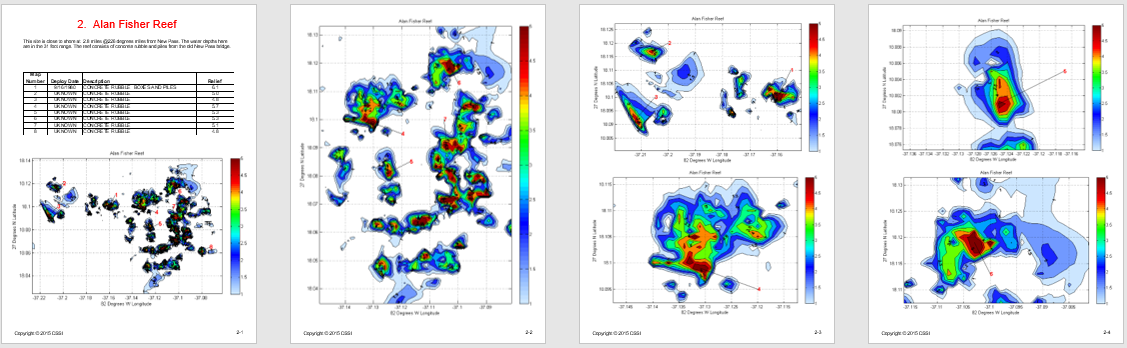
Contours charts of the bottom include 1/2-foot contour lines which identify the depth. The various depths are color coded from blue areas being the deepest section and red being the shallowest areas and indicate the underwater pinnacles and ledges that attract fish and coral.

The website is divided by Florida Counties. We currently have sites off the counties that are featured on tabs on the top of the screen and highlighted in green in the Florida Map below. For example, sites directly off Sarasota county are shown on the Sarasota page under the Sarasota tab on the top of the page. You can select the county by clicking your mouse on the county on the Florida map and you will be directed to that area. On that map you will see small red x's, indicating the reefs and wrecks that have been scanned and available for your purchase and download. Clicking a little red X will bring you directly to that reef.
After selecting the reefs and wrecks you want, you pay on line and download the waypoints and charts immediately to your computer. No waiting, shipping costs or taxes. Other reefs are being scanned and added to the website monthly. Please check back often to see the new and interesting sites.
What are Detailed Nautical Reef Charts
The picture on the left below shows the lack of detail of a standard NOAA chart. You can see that the reef is shown only as a small light blue half circle and labled as a Fish Haven with a minimum authorized depth. It does not show any detail as to the location of structure, which is imperative for fishing and diving. So we scanned the bottom of the entire reef areas with sonar for many hours and then processed the data to produce our Detailed Nautical Reef Charts. (Zoomed in view seen on the right). Now you know exactly where to go fishing or diving, no hunting around looking on your depth sounder. Move around and check out all the structures in the area not just one or two waypoints you got from a friend. See your boat positioned right on the charts (shown with range rings on) in real time as you move around and anchor up.

How To Use The Charts
Brighter reds have greater profiles (peaks) while light blues have lower profiles. The color key scale on the right indicates the respective reliefs. The left side of the map indicates the GPS latitude (North-South) and the bottom of the map indicates the GPS longitude (East-West) coordinates. Each reef contains a numeric key, the date it was deployed, a description and the relief in feet off the bottom. Know what is on the bottom before you drop anchor, and when you do, drop it right where you want it!

Formats available:
NOTE: All downloadable files are packaged in a self extracting ZIP file with the .EXE extension. This file can only be extracted on a Microsoft Windows platform. The file cannot be extracted on a tablet or Apple computer without special software that allows it to run Windows programs. The .EXE file must be run to accept the license agreement, specify a file folder and automatically UNZip them for use. Never load the raw .EXE file into any non Windows device.
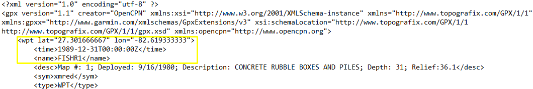
The GPX file which contains only the latitude and longitude of all the waypoints associated with that particular reef. There are no nautical charts included with the file, only waypoints. The waypoints are chosen to be in the center of each large pile of reef material, or a number of interesting spots along a particular ledge or wreck. Each waypoint contains a description of the material or reef that is at the waypoint, the depth and relief off the bottom. (Example of GPX file below.) Most GPS units will accept an import of a GPX file. Check with the manufacturer of your GPS unit for detailed instructions for loading a GPX file into your chartplotter. The GPX User Manual explains how to use the file and can be downloaded for FREE by selecting (SAMPLE) by any GPX file selection or this link: GPX User Manual
The KAP format is the same format as all standard NOAA raster charts and can be used in many chart navigation programs. As you zoom into a smaller and smaller area, our detailed reef and wreck charts will open and display exactly what is on the bottom. All the charts show details with resolution down to .001 minute (6ft). This format is used with OpenCPN on a PC or with SeaIQ Open on an iPad/iPhone or Android device. The KAP User Manual explains how to use the file and can be downloaded for FREE by selecting (SAMPLE) by any KAP file selection or this link: KAP User Manual

The KMZ format is used with Garmin hand held GPS units and on a PC with Garmin Homeport and Google Earth. The KMZ User Manual explains how to use the file and can be downloaded for FREE by selecting (SAMPLE) by any KMZ file selection or this link: KMZ User Manual

The PDF Format is formatted to let you print out the pages and bring them with you fishing or diving. The pages are laid out with a description of the reef and a table of callouts with deploy data, reef description and height off the bottom or relief. Place the pages in plastic sleeves or laminate them for use on the boat. Bring them with you on a friends boat or your own if you want a simple hard copy way to view the detailed reef charts. The PDF User Manual explains how to use the file and can be downloaded for free by selecting (SAMPLE) by any PDF file selection or clicking this link: PDF User Manual
The QDC format (Quickdraw Contours) is used with Garmin marine GPS units. Refer to the Garmin website to check if your marine depth sounder is compatable with Garmin Quickdraw Contours. The QDC User Manual explains how to use the file and can be downloaded for FREE by selecting (SAMPLE) by any QDC file selection of clicking this link: QDC User Manual.

The AT5 format (Atlas Version 10) is used with Lowrance, Simrad and B&G marine GPS units. Refer to the Lowrance, Simrad and B&G website to check if your marine depth sounder is compatable with the AT5 Version 10 raster charts. The AT5 User Manual explains how to use the file and can be downloaded for FREE by selecting (SAMPLE) by any AT5 file selection or this link: AT5 User Manual The picture below is a screen shot taken from a Lowrance HDSLive Chartplotter.

GPX files start at $2.99 and the KAP, KMZ, PDF, AT5 and QDC files are only an additional $1.99. The GPX file is included in all formats. You can order multiple formats at the same time for only $1.99 more and save some money.
Go to the Sarasota tab, select Fisher Reef and download all the available file formats for FREE ($.08) and give it a try. You will be amazed at the detail and accuracy of our Detailed Nautical Reef charts.