Manatee

Manatee county covers the area North of University Parkway and the Sarasota Bradenton Airport to the northern tip of Anna Maria Island. The area has many artificial and natural reefs from 3 Mile South in the south to the various pipeline reefs in the North. Each reef description will tell you the distance from a well know landmark so you can get a good idea how far out it is.
-
 1 Mile Reef$2.99
This is an artificial reef that covers an area of 0.27 X 0.46 miles and consists of thousands of tons of bridge material, concrete culverts and reefballs put down between 1992 and 2005. This reef is close to shore at 1.5 miles west of Bradenton Beach and 4.3 miles at 320 degrees from Longboat Pass entrance and 3.4 miles at 169 degrees tip of Anna Maria Island. The water depths here are in the 25 foot range and has a maximum relief of 5.7 feet off the bottom.
Learn More -
 3 Mile North Reef$2.99
This is an artificial reef that covers an area of 0.30 X 0.51 miles in two sections one half mile apart and consists of concrete culverts and fiberglass boat molds put down in 1987. This site is close to shore at 3.4 miles at 221 degrees from the NW tip of Anna Maria Island and 7.0 miles at 305 degrees from Longboat Pass. The water depths here are in the 28 foot range and has a maximum relief of 4.7 feet off the bottom.
Learn More -
 3 Mile South Reef$2.99This is an artificial reef that covers an area of 0.30 X 0.51 miles and consists of concrete pilings, culverts, panels and reef balls put down between 1997 and 2004. This site is close to shore at 3.5 miles at 270 degrees from Longboat Pass. The water depths here are in the 30 foot range and has a maximum relief of 7.4 feet off the bottom. Learn More
 -
 7 Mile North Reef$2.99This is an artificial reef that covers an area of 0.30 X 0.51 miles and consists of concrete pyramids and rubble and put down between 1976 and 2008. This site is off shore at 8.2 miles at 270 degrees from the NW tip of Anna Maria Island. The water depths here are in the 40 foot range and has a maximum relief of 7.5 feet off the bottom. Learn More
 -
 7 Mile South Reef$2.99This is an artificial reef that covers an area of 0.31 X 0.54 miles and consists of over 1600 tons of concrete culverts, beams, light poles, reefballs and a 110 ft long steel barge put down between 1976 and 2002. This site is 7.9 miles at 214 degrees of NW tip of Anna Maria Island and 8.0 miles at 270 degrees from Longboat Pass. The water depths are in the 40 foot range and has a maximum relief of 7.4 feet off the bottom. Learn More
 -
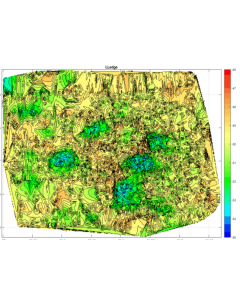
 Anna Maria Ledge$2.99This is a natural ledge reef that covers an area of 0.21 X 0.18 miles and consists of a natural ledge and has a 2 to 3 foot relief. This site is 10.6 miles at 260 degrees from the North tip of Anna Maria Island and 14.7 miles at 290 degrees from Longboat Pass. The water depths here are in the 46 foot range. Learn More
 -
 Bayshore North Reef$2.99This is an artificial reef that covers an area of 113 feet X 188 feet and consists of 162 reefballs put down in 2004. This site is on the North Eastern side of Sarasota Bay near BayshoreGardens in around 10 feet of water and has a maximum relief of 2.5 feet. Learn More
 -
 Bayshore South Reef$2.99This is an artificial reef that covers an area of 357 X 339 feet and consists of 243 concrete reefballs blocks put down in 2004. This site is in North Sarasota Bay, west of the Sarasota airport. The water depths here are in the 10 foot range with a maximum relief of 2.5 feet off the bottom. Learn More
 -
 Bulkhead Reef$2.99This is an artificial reef that covers an area of 0.16 X 0.29 miles and consists of 170 concrete reefballs put down in 2004.This site is 2.5 miles at 67 degrees off the NW tip of Ann Maria Island. The water depths here are in the 15 foot range with a maximum relief of 1.4 feet off the bottom. Learn More
 -
 Docs Barge$2.99This is an artificial reef that is also called the Shrimp Barge and the Chemical Barge, covers an area of 0.12 X 0.11 miles and consists of a barge that is upside down and very broken up. This site is close to shore at 14.9 miles at 261 degrees from the NW tip of Anna Maria Island and 18.7 miles at 283 degrees from Longboat Pass. The water depths here are in the 59 foot range with a maximum relief of 8.4 feet off the bottom. Learn More
 -
 Docs Ledge$2.99This is a natural ledge reef that covers an area of 0.28 X 0.23 miles This site is 13.2 miles at 265 degrees from the northern tip of Anna Maria Island and 17.5 miles at 288 degrees from Longboat Pass. The water depths here are in the 55 foot range with a 3 foot relief. Learn More
 -
 Emerson Point$2.99This is an artificial reef that covers an area of 0.14 X 0.15 miles and consists of 81 concrete reefballs. This site is right at the mouth of the Manatee River 6 miles at 95 degrees from the NW tip of Anna Maria Island in 12 feet of water with a maximum relief of 3 feet. The area is a deeper 16 ft hole surrounded by shallow water. Learn More
 -
 Fin Barge$2.99
This is an ship wreck that covers an area of 469 X 445 feet and consists of a large upside down barge that has two large fins, which helped stabilize the craft while it was being towed. This site is 21.7 miles at 262 degrees from NW tip of Anna Maria Island and 25.1 miles at 278 degrees from Longboat Pass. The water depths here are in the 78 foot range with a maximum relief of 20 feet.
Learn More -
 Gucken Reef$2.99
This is an artificial reef that covers an area of 0.2 miles X 0.2 miles and consists of concrete culverts and a 120' steel barge put down in 2020. This site is 4.6 miles @ 250 degrees from the tip of Anna Maria Island in around 33 feet of water and has a maximum relief of 5.3 feet.
Learn More -
 Gunsmoke Ledge$2.99This is a natural ledge reef that covers an area of 0.36 X 0.34 miles and consists of a natural ledge and the ship wreck of the shrimp boat Gunsmoke. This reef is 21 miles at 274 degrees off of the NW tip of Anna Maria Island and 25.6 Miles at 288 degrees from Longboat Pass entrance. The water depths here are in the 76 foot range and has a maximum relief of 5 feet. Learn More
 -
 Jim Ledge$2.99This is a natural ledge reef that covers an area of 0.32 X 0.26 miles. This reef is 13.5 miles at 238 degrees from the northern end of Anna Maria Island and 15.1 Miles from Longboat Pass entrance. The water depths here are in the 57 foot range and has a maximum relief of 4.7 feet. Learn More
 -
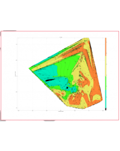
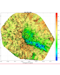
 Jody Ledge$2.99This is a natural ledge reef that covers an area of 0.46 X 0.36 miles. This site is 9.4 miles at 245 degrees from the North tip of Anna Maria Island and 12.3 miles at 282 degrees from Longboat Pass. The water depths here are in the 40 foot range and has a maximum relief of 3.0 feet. Learn More
 -
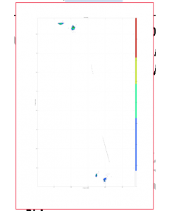
 Jody Little Ledge$2.99This is a natural ledge reef that covers an area of 0.16 X 0.14 miles. This site is 7.8 miles at 239 degrees from the North tip of Anna Maria Island and 10.6 miles at 285 degrees from Longboat Pass. The water depths here are in the 43 foot range and has a maximum relief of 2.8 feet. Learn More
 -
 L Ledge$2.99This is a natural ledge reef that covers an area of 0.38 X 0.29 miles. This reef is 12.5 miles at 261 degrees from the northern end of Anna Maria Island and 16.5 Miles at 286 degrees from Longboat Pass entrance. The water depths here are in the 53 foot range and has a maximum relief of consist of a 3 feet. Learn More
 -
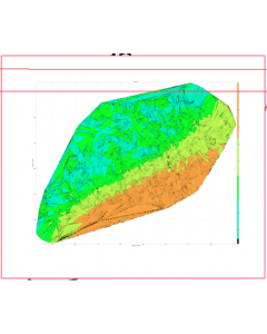
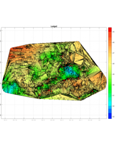 Ledge 2$2.99This is a natural ledge reef that covers an area of 0.58 X 0.50 miles. This site is 11.8 miles at 263 degrees from the North tip of Anna Maria Island and 16.0 miles at 288 degrees from Longboat Pass. The water depths here are in the 53 foot range and has a maximum relief of 4 feet. Learn More
 -
 Ledge 8$2.99This is an artificial reef that covers an area of 0.48 X 0.43 miles. This site is 11.3 miles at 266 degrees from the North tip of Anna Maria Island and 15.8 miles at 291 degrees from Longboat Pass. The water depths here are in the 53 foot range and has a maximum relief fo 3 feet. Learn More
 -
 Matrix Ledge$2.99This is a natural ledge reef that covers an area of 0.15 X 0.24 miles. This site is 22.7 miles @ 253 degrees from the North tip of Anna Maria Island and 25.2 miles @ 270 degrees from Longboat Pass. The water depths here are in the 89 foot range and has a maximum relief of 3 feet. Learn More
 -
 Misener Barge$2.99This is an artificial reef that covers an area of 0.25 X 0.22 miles and consists of a large steel barge put down in 1985. This site is 11.8 miles at 263 degrees from the North tip of Anna Maria Island and 16.0 miles at 288 degrees from Longboat Pass. The water depths here are in the 53 foot range with a maximum relief of 3.6 feet. Learn More
 -
 Near Shore Reef$2.99This is an artificial reef that covers an area of 0.18 X 0.31 miles and consists of 1500 tons of concrete bridge span material with low 1 to 5 foot relief and put down in 1993. This site is 0.2 miles from the shore near Leffis Key and 0.6 miles at 321 degrees of Longboat Pass. The water depths here are in the 16 foot range with a maximum relief of 4.9 feet off the bottom. Learn More
 -
 Peaks Reef$2.99This is an artificial reef that covers an area of 0.65 X 0.62 miles and consists of a mountain of dredged material from the Tampa shipping channel and rises 20 feet off the surrounding bottom. This reef is 20.5 miles at 267 degrees from the northern end of Anna Maria Island and 24.61 Miles at 283 degrees from Longboat Pass entrance. The water depths here are in the 50 to 77 foot range and has a maximum relief of 28.8 feet off the bottom. The top surface has rocks and pieces of concrete forming a nice reef. Learn More
 -
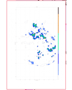
 Pipeline 1 Reef$2.99This is an artificial reef that covers an area of 0.16 X 0.20 miles and consists of tons of rocks put down in 2002. This is one of the gas pipeline mitigation reefs. This site is 13.3 miles at 93 degrees from the northern tip of Anna Maria Island and 20.3 miles at degrees from Longboat Pass. The water depths here are in the 56 foot range with a maximum relief of 3.0 feet. Learn More
 -
 Pipeline 2 Reef$2.99This is an artificial reef that covers an area of 0.62 X 0.31 miles and consists of tons of rocks put down in 2002. This is one of the gas pipeline mitigation reefs. This site is 23.7 miles at 279 degrees from the northern tip of Anna Maria Island and 28.5 miles at 291 degrees from Longboat Pass. The water depths here are in the 80 foot range and has a maximum relief of 8.1 feet off the bottom. Learn More
 -
 Pipeline 3 Reef$2.99This is an artificial reef that covers an area of 350 X 336 feet and consists of dredged material and rocks and was put down in 2002. This is one of the gas pipeline mitigation reefs. This site is 21.6 miles at 277 degrees from the northern tip of Anna Maria Island and 26.5 miles at 291 degrees from Longboat Pass. The water depths here are in the 75 foot range with a maximum relief of 1.3 feet off the bottom. Learn More
 -
 Pipeline 4 Reef$2.99This is an artificial reef that covers an area of 0.13 X 0.17 miles and consists of tons of rocks put down in 2002. This is one of the gas pipeline mitigation reefs. This site is 23.7 miles at 279 degrees from the northern tip of Anna Maria Island and 28.5 miles at 291 degrees from Longboat Pass. The water depths here are in the 51 foot range and has a maximum relief of 3.9 feet off the bottom. Learn More
 -
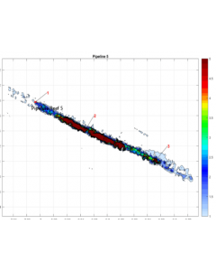 Pipeline 5 Reef$2.99This is an artificial reef that covers an area of 0.301 X 0.24 miles and consists of tons of rocks in a straight line pile and put down in 2002. This is one of the gas pipeline mitigation reefs. This site is 23.0 miles at 278 degrees from the northern tip of Anna Maria Island and 28.0 miles at 291 degrees from Longboat Pass. The water depths here are in the 77 foot range with a maximum relief of 8.7 feet off the bottom. Learn More