Search results for: '1%2527+and'
-
 Gunsmoke Ledge$2.99This is a natural ledge reef that covers an area of 0.36 X 0.34 miles and consists of a natural ledge and the ship wreck of the shrimp boat Gunsmoke. This reef is 21 miles at 274 degrees off of the NW tip of Anna Maria Island and 25.6 Miles at 288 degrees from Longboat Pass entrance. The water depths here are in the 76 foot range and has a maximum relief of 5 feet. Learn More
 -
 Docs Barge$2.99This is an artificial reef that is also called the Shrimp Barge and the Chemical Barge, covers an area of 0.12 X 0.11 miles and consists of a barge that is upside down and very broken up. This site is close to shore at 14.9 miles at 261 degrees from the NW tip of Anna Maria Island and 18.7 miles at 283 degrees from Longboat Pass. The water depths here are in the 59 foot range with a maximum relief of 8.4 feet off the bottom. Learn More
 -
 Walker Reef$2.99This is an artificial reef covering a 0.62 x 0.93 mile area. The reef consists of 655 concrete reef balls and boulders put down between 1999 and 2002. This site is 3.6 miles @309 degrees from Sarasota Centennial Boat Ramp. The water depths here are in the 12 foot range. Learn More
 -
 Roeher Reef$2.99This is an artificial reef covering a 245 x 340 foot area. The reef consists of concrete rubble form the old Orange Ave Bridge and put down in 1981. This site is close to shore at 1.7 miles @ 187 degrees from New Pass. The water depths here are in the 22 foot range and has a maximum relief of 6.5 feet off the bottom. Learn More
 -
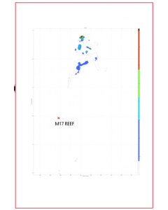 M17 Reef$2.99This is an artificial reef covering a 0.21 x .3 mile area. The reef consists of concrete culverts and 120 reef balls put down in 1995. This site is 12.0 miles @ 246 degrees from Venice Inlet. The water depths here are in the 60 foot range and has a maximum relief of 3.6 feet off the bottom. Learn More
 -
 M15 Reef$2.99This is an artificial reef covering a 0.1 mile square area. The reef consists of 2200 tons of concrete culverts and rubble, some mixer drums put down in 1991. This site is 5.0 miles @246 degrees from Venice Inlet. The water depths here are in the 38 foot range and has a maximum relief of 9 feet off the bottom. Learn More
 -
 M14 Reef$2.99This is an artificial reef covering a 460 foot square area. The reef consists of hundreds of tons of concrete culverts put down in 2007. This site is 16.8 miles @ 173 degrees from the Venice Inlet and 6.3 miles @ 253 degrees from Stump Pass. The water depths here are in the 43 foot range and has a maximum relief of 7.2 feet off the bottom. Learn More
 -
 M9 Reef$2.99This is an artificial reef covering a 0.31 x 0.52 mile area. The reef consists of six M60 Army tanks put down in 1995 and tons of concrete rubble. This site is 14.6 miles @ 258 degrees from Venice Inlet. The water depths here are in the 64 foot range and has a maximum relief of 9.1 feet off the bottom. Learn More
 -
 M5 Reef$2.99This is an artificial reef covering a 500 foot square which consists of consists of 600 tons or oval and round concrete culverts put down in 1994 . This site is 10.8 miles @ 228 degrees from New Pass. The water depths here are in the 40 foot range and has a maximum relief of 17 feet off the bottom. Learn More
 -
 M2 Reef$2.99This is an artificial reef covering a 0.12 mile square and consisting of tons of concrete culverts and boxes put down starting in 1990 with a relief up to 5.3 feet. It is 7.9 miles @ 261 degrees from New Pass. The water depths here are in the 38 foot range. Learn More
 -
 M1 Reef$2.99This is an artificial reef covering a 0.23 mile square and consists of a 110' x 30' barge put down in 1987 and over a thousand tons of concrete culvers put down starting in 1993. This site is 8.2 miles @261 degrees from New Pass. The water depths here are in the 39 foot range. Learn More
 -
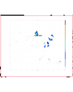 Hart Reef$2.99This is an artificial reef and consists of 820 cubic yards of concrete block put down in 1989, broken concrete block put down in 1993 and 75 bay balls put down in 1997. It has a very low profile due to the shallow depth.This site is 2.2 miles @ 317 degrees from Sarasota Centennial Park Ramp. It is in South Sarasota Bay, East of the Intercostal Waterway. The water depths here are in the 10 foot range. Learn More
 -
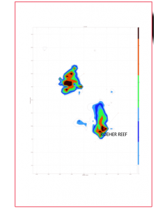
 Fisher Reef$0.08FREE! This is an artificial reef consists of concrete rubble, boxes and piles from the old New Pass bridge and put down starting in 1980. This site is close to shore at 2.8 miles @226 degrees miles from New Pass. The water depths here is in the 31 foot range. Learn More
 -
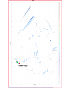 Helen Reef$2.99This is an artificial reef that covers an area of 0.21 X 0.36 miles and consists of four 60 foot long steel barges put down in 2001. This site is 5.7 miles at 195 degrees from Boca Grande Pass. The water depths here are in the 30 foot range and has a maximum relief of 4.6 feet off the bottom. Learn More
 -
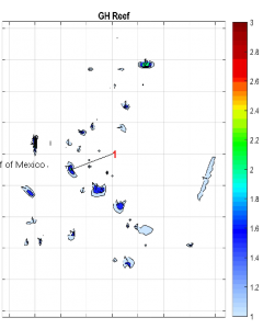 GH Reef$2.99This is an artificial reef that covers an area of 0.09 X 0.11 miles and consists of concrete culverts put down in 1995. This site is 10.4 miles at 162 degrees from Punta Rassa boat ramp or 8.4 miles at 156 degrees from the east end of Sanibel Island. The water depths here are in the 28 foot range and has a maximum relief of 2.4 feet off the bottom. Learn More
 -
 Danger Reef$2.99This is an artificial reef that covers an area of 268 X 264 feet and consists of a small steel tug wreck put down in 1998. This site is about 2.2 miles at 227 degrees from the southern most tip of Cape Haze. The water depths here are in the 12 foot range and has a maximum relief of 4.5 feet off the bottom. Learn More
 -
 Port Manatee Reef$2.99This is an artificial reef consisting of over 3000 tons of concrete culverts, blocks, bridge decking and rails put down between 1991 and 2004. This site is close to shore in Tampa Bay, 1.8 miles @230 degrees from Bahia Beach Marina. The water depths here are in the 20 foot range with a maximum relief of 8.5 feed off the bottom. Learn More
 -
 Picnic Reef$2.99This is an artificial reef consisting of 1660 yards of concrete culverts and 54 tons of concrete pyramid modules put down between 1987 and 1991. This site is close to shore in Tampa Bay. The first site is just east of a sand shoal. The second site is 100 ft West of Picnic Island fishing pier. The water depths here are in the 26 foot range with a maximum relief of 6.6 feet off the bottom. Learn More
 -
 Howard Franklin Reef$2.99This is an artificial reef consisting of 320,000 yards of concrete bridge rubble put down in 1991. This site is in Old Tampa Bay, 1.9 miles south of the Howard Franklin Bridge and 1.3 miles west of the Interbay Peninsula, between the Howard Franklin and Gandy Bridges. The water depths here are in the 16 foot range with a maximum relief of 7.2 feet off the bottom. Learn More
 -
 Bahia Reef$2.99
This is an artificial reef consisting of tons of concrete pilings, slabs, and culvert pipe put down between 1989 and 2006. This site is in Tampa Bay, 2.1 miles @ 305 degrees off of Mangrove Pt. North of Bahia Beach. The water depths here are in the 20 foot range with a maximum relief of 7.6 feet off the bottom.
Learn More -
 Drop Reef$2.99This is a natural ledge that drops fairly quickly from 45 feet to 83 feet and contains sand channels and natural corals. The chart covers an area .25 miles x .15 miles. This site is 5.9 miles at 106 degrees from Caesar Creek Pass near Adams Key. Strong currents are sometimes present. Learn More
 -
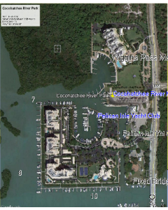 Cocohatchee Boat Ramp$0.99Cocohatchee River Park is a 7 acre property on Vanderbilt Drive located between 111th Avenue (Immokalee Road) and Bonita Beach Road. The park provides access to the gulf of Mexico through Wiggins Pass. Cocohatchee River Park has more capacity than other boat launches with many parking spaces and four boat launching lanes. Learn More
 -
 Sulfur Barge$2.99This is an artificial reef that covers an area of 524 X 441 feet and consists of a barge that is broken up and the top has caved in. It was sunk in 1997. This site is 24 miles at 275 degrees from the northern tip of Anna Maria Island. The water depths here are in the 54 foot range with a maximum relief of 6.5 feet. Learn More
 -
 South East Tampa Reef$2.99This is an artificial reef that covers an area of 240 X 447 feet and consists of 160 concrete reefballs put down in 2004. This site is 4.5 miles at 81.6 degrees off the NW tip of Anna Maria Island in around 14 feet of water and has a maximum relief of 8.9 feet. Learn More
 -
 Misener Barge$2.99This is an artificial reef that covers an area of 0.25 X 0.22 miles and consists of a large steel barge put down in 1985. This site is 11.8 miles at 263 degrees from the North tip of Anna Maria Island and 16.0 miles at 288 degrees from Longboat Pass. The water depths here are in the 53 foot range with a maximum relief of 3.6 feet. Learn More
 -
 Bayshore North Reef$2.99This is an artificial reef that covers an area of 113 feet X 188 feet and consists of 162 reefballs put down in 2004. This site is on the North Eastern side of Sarasota Bay near BayshoreGardens in around 10 feet of water and has a maximum relief of 2.5 feet. Learn More
 -
 Clearwater Wreck$2.99This reef is an artificial reef that covers an area of 0.14 X 0.13 miles which consists of a steel ship wreck. This reef is 17.8 miles at 267 degrees from Clearwater Pass and 23.9 miles at 300 degrees from John’s pass. The water depths here are in the 60 foot range with a maximum relief of 9.4 feet off the bottom. Learn More
 -
 MD1 Reef$2.99This is an artificial reef covering a 0.25 x .41 mile area. The reef consists of a upside down barge and a concrete filled hopper barge. This site is 25.9 miles @ 277 degrees from New Pass and 21.5 miles from Venice Inlet. The water depths here are in the 80 foot range and has a maximum relief of 5.3 feet off the bottom. Learn More
 -
 Trouble Ledge$2.99This reef is a natural ledge which covers and area of 0.21 X 0.30 and has a high area in the middle. The reef is 18.9 miles @261 degrees from Clearwater Pass and 23 miles @ 296 degrees from John’s pass. The water depths here are in the 70 foot range with a maximum relief of 4 feet. Learn More
 -
 Doc Kline Reef$2.99This is an artificial reef that covers an area of 0.25 X 0.28 miles and consists of 2 piles (36 Total) of 30 ft. long concrete pilings put down in 2000. This site is 12.5 miles at 205 degrees from the Punta Rassa Boat Ramp and 5.7 miles South of Sanibel Island. The water depths here are in the 30 foot range and has a maximum relief of 5.8 feet off the bottom. Learn More